Flows in the Eel River and the Potter Valley Project
(Click on any graph to enlarge.)
 The upper Mainstem Eel River is a rain-driven watershed, collecting enormous amounts of water during significant winter and spring storms. Therefore, during the rainy season, the river quickly swells and then recedes until the next storm.
This area of California, the southernmost section of the Eel River watershed, only rarely receives rain in summer. Early summer flows are produced from snow and retained groundwater, and snow only persists on peaks over 5,000' in this region. Only Hull Mountain and Snow Mountain hold snow into the spring.
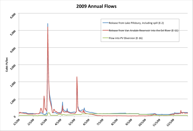
This chart, showing annual flows in the Eel River, clearly shows how variable the flow was in the relatively dry year of 2009. The peak flow, as measured passing Cape Horn Dam at gage E-11, for one day, was over 5,000 cfs, quickly dropping to approximately 1,000 cfs and then back to the winter steady state of around 150 cfs before the next major rain. Peak winter flows can occasionally exceed 100,000 cfs. It is these winter storm events that are captured and stored in Lake Pillsbury for later use.
 This is another view of the same graph, with the peak flows allowed to go off the chart to enable a better view of the ordinary day to day actual flows. The green line shows flows into the PVP. If you compare the dates of this graph to the Lake Pillsbury storage graph below, it is clear that the water for that diversion is not at the expense of natural flows down the Eel, but is maintained from the early season storage behind Scott Dam.
 The flow rate required for each day also takes into account the level of water storage at Lake Pillsbury. The gates on the dam are typically open in winter months to maintain the State Division of Dam Safety required flood control pool until April 1st. The RPA target storage curve has a preferred lake elevation for every day of the year, and flows through the Potter Valley Project are reduced when Lake Pillsbury falls below this level.
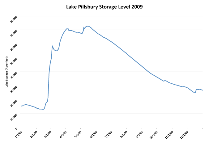
Comparing this chart to the ones above, you can clearly see how the peak events were used to fill the dam.
Between October 16th and April 1st, (winter season) the gates on Scott Dam are kept open. This means maximum lake storage, at the dam spill crest at an elevation of 1900 feet, equals 54,338 acre feet. All flows after this free flow over the top as if the dam wasn't there. As long as the RPA target storage level for Lake Pillsbury remains below 54,338 acre feet for that date, the Potter Valley Project diversion at E-16 can be increased above the minimum. On the day the target curve climbs above 54,338 acre feet, the E-16 diversion drops to the RPA required minimum of 40 CFS. That date, under normal year conditions, is March 8th, regardless of the spill rate over the dam. Even though a significant amount of water is flowing down the Eel River towards Van Arsdale, if Lake Pillsbury is below its target storage level for that date, water cannot be sent through the diversion.
The top gates on Scott Dam cannot be closed until April 1st, for dam safety reasons. Due to the conflicting regulations, the required target storage for the lake continues to climb while another set of rules require that the dam gates are wide open, preventing further water accumulation. Even after the flood gates are closed, April 1st through October 15th, all RPA required minimums must be met. The target storage curve continues to rise. The elevation of the top of the gates is 1910 feet which equals 74,993 acre feet of storage. PG&E must hold storage to 1909 feet which equals 72,744 acre feet, to ensure that water never overtops the gates. After this level, the target storage curve continues to climb into mid air above the dam to an unattainable level of 83,300 acre feet! Per the 2006 bathymetric survey, the maximum storage at the lake is 74,993 acre feet.
One cubic foot per second (CFS) = Two acre feet (AF) in 24 hours.
At in-flows of 5,000 CFS, Lake Pillsbury, if it was completely empty, would fill to the spill crest and overflow in approximately 5.5 DAYS. Given that it usually retains some water in summer, typically 3 days at 5,000 cfs will raise the lake to 55,000 acre feet. Lake Pillsbury's minimum pool historically remains above 20,000 acre feet. In 2009, storage reached a low of 13,500 acre feet, the lowest since 1977.
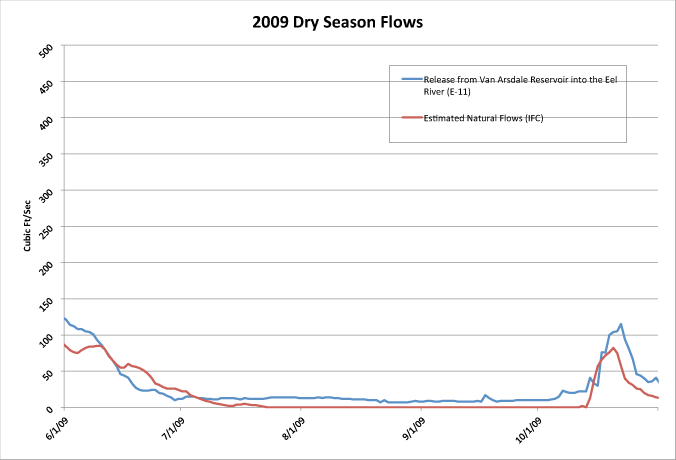 Below the dams, releases during the dry months are designed to mimic or slightly exceed natural flows. The calculations used to create these minimum flows were developed by NOAA Fisheries, and are found in the RPA Appendix A.
Some natural variation in the river is lost due to the dams, but on the other hand, some of that natural variation could include severe droughts that would reduce the upper Eel River to a trickle. Water stored at Lake Pillsbury assures that there is always water to release the rates required by the National Marine Fisheries Service (NMFS).
Every night, a report that is required by FERC is produced by PG&E for the Potter Valley Project showing all the flows, lake elevations, storage, weather, and general system status for the project. This in turn is used to regulate flow rate management for the next day. Sample Nightly Report (79K PDF)
Releases below Cape Horn Dam on the Eel River mimic natural flows and minimum flows are maintained, or exceeded, for the entire summer time period. The summer releases through the Project, into the Potter Valley Powerhouse, would not exist unless winter and spring water was stored in Lake Pillsbury. Most precipitation in the Upper Eel River falls as rain during the winter and spring; only snow above 5000' provides any summer contribution to the water supply. Before Scott Dam was built, there were no summer flows through the Potter Valley Project, and extremely low natural flows below Van Arsdale.
Winter flows, on the other hand, can be enormous and spike rapidly during a significant winter storm. A typical summer flow out of Van Arsdale might be 20 cfs, but during a winter storm, the flow over that point is frequently greater than 7,000 cfs.
Releases from Van Arsdale are intended to mimic natural flows, and are calculated using the formulas described in the document below:
RPA Appendix A - NOAA fisheries' 2002 Biological Opinion and the Reasonable and Prudent Alternative minimum flows of the Eel River.